


The following article is an excerpt of the Browning Newsletter, a key source of information in describing the relationship between macro weather-related trends and their potential impact upon energy, commodities, and the wider global economy. To subscribe to her montly newsletter, CLICK HERE.
SUMMARY
The new La Niña that is developing in the Pacific will have the impact of a strong event. Expect North America to have another cold winter.
You’ve seen the headlines. The Northeast was hit by a Nor’easter snowstorm that affected 60 million people. Over three million were left without power and outages to last for days. New York City received its earliest inch of snow since the Civil War. Pennsylvania, Washington DC and the entire Northeast were buried in as much as two feet of snow and then hit by freezing weather.
The Northeast is not the only cold area. Even Texas, already drought-stricken, had snow this month in Amarillo. The Rocky Mountains, including my home 300 miles from the Mexican border, has been buried in white stuff two times in October. Sunny California started the month with heavy rain in the Fresno valley (hammering the drying raisin crop) and snow for the ski resorts in the Sierra Nevadas. And it is all due to hot water and cold, cold air.
We are being hit by a La Niña and a “wild card”. Welcome to the early beginning of the winter of 2011/2012.
The Official Forecast
On October 20, the U.S. Climate Prediction Center issued its outlook for the winter of 2011/2012. It focused on the recent arrival of a new La Niña in the tropical Pacific and the impact of that phenomenon on American weather. However, it warned that the frozen polar air of the Arctic Oscillation could be a “wild card”. Let’s look at this prediction.
The government forecasters see a schizophrenic winter. According to the annual Winter Outlook released by NOAA the Southern Plains will continue to be warmer and drier than normal, while the Pacific Northwest will be colder and wetter than average. From December through February, the entire southern tier of states will have below normal precipitation, while the northern states will have above normal snow from the Pacific through the Great Lakes. The same northern region and the West Coast will have below normal temperatures. Meanwhile, the Mid-Atlantic States and the Northeast will be near normal. After last winter’s blizzards, the forecast will be a relief to New York and Pennsylvania.
The forecast warns that the major “wild card” in this projection is the Arctic Oscillation. In the NOAA’s words:
The Arctic Oscillation is always present and fluctuates between positive and negative phases. The negative phase of the Arctic Oscillation pushes cold air into the U.S. from Canada. The Arctic Oscillation went strongly negative at times the last two winters, causing outbreaks of cold and snowy conditions in the U.S. such as the “Snowmaggedon” storm of 2009. Strong Arctic Oscillation episodes typically last a few weeks and are difficult to predict more than one to two weeks in advance.
The Browning Newsletter agrees with much of this analysis. The La Niña in the Tropical Pacific will be a dominant factor shaping this winters weather. However, we routinely include other factors, some of which will trigger the “Wild Card” Arctic Oscillation to plunge abnormally far south for a third year in a row.
The La Niña Factor
Last year, one of the major factors that created last year’s cold winter in North America was a strong La Niña.
This year’s La Niña will be stronger!
A La Niña is when the Tropical Pacific is 0.5˚C (0.9˚F) cooler than normal. A moderate La Niña is around 1.0˚C (1.8˚F) and a strong event is 1.5˚C (2.7˚F) cooler than average. Last year the La Niña hovered between 1.5˚ and 2.0˚C (2.7˚ − 3.6˚F) all winter long. It began to weaken in January and was officially gone by June.
The Tropical Pacific began to cool again in late August and by mid-September, officials declared a La Niña condition.
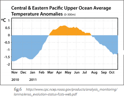 It will have to continue for 5 weeks in a row to officially be declared a La Niña event. As Figure 6 shows, water temperatures can flicker into warm El Niño or cool La Niña territory. However if it doesn’t last for multiple months, then there is no long-term significant impact on climate.
What is the impact of the current La Niña?
The strong La Niña traditionally strengthens the South Asian monsoon. This has caused the massive flooding in Thailand. The event both strengthened and prolonged the nation’s wet season, causing the worst flooding in 50 years.
These floods are going to have a major global economic impact. Southeast Asia is the main source of rice exports. According to the October 25th edition of the Wall Street Journal, Thailand has had 12.5% of its total rice farmlands damaged in Thailand alone. In Cambodia, 12% of paddy fields have been destroyed, with another 7.5% in Laos and 6% in the Philippines.
Additionally, Thailand manufactures one-fourth of the world’s hard drives and half of the HDD for PCs. The floods have shut down more than 14,000 factories and forced at least 660,000 people out of work.
Closer to home, the return of La Niña has prolonged the drought in the Southern US. 100% of Texas, more than 85% of the South Central states and more than 53% of the Southeastern states are in drought. Ranchers are cutting back their herds across the Southern Plains. While in the short run this will reduce beef prices, it will take years for the herds to recover. Prepare for the price of your hamburger to rise.

The combination of a hot Atlantic and cold La Niña waters in the East Pacific coastline, sets up a pattern of winds that tend to steer tropical Atlantic storms straight into Mexico/Central America or up the middle of the Atlantic. This steers the storms away from the US oil and gas production fields in the Gulf of Mexico. During the short intermission between the last La Niña and this one, Irene ripped up the Atlantic Coast and TS Lee shut down more than 60% of the Gulf ’s oil production and 40% of gas production.
Going back to Asia – the summer disappearance of La Niña allowed Northern China to have an excellent corn crop. The reappearance of La Niña is creating wet harvest conditions for huge areas of the crop. Since China lacks an efficient, nationwide cold storage transportation network, the result will be high spoilage rates and poor quality for those goods finding their way to market. Last year’s autumn La Niña created some of the same difficulties including disease and vomitoxin in feed, have still not fully been resolved. China is still catching up on grain supplies. This return of the phenomenon will increase the nation’s problem, and we will see the problem become more severe through winter into spring.
Currently scientists are divided on how strong this event will grow. There is a consensus that this episode will last into spring. Initially most models projected a weak event but the majority now forecast a moderate event. Figure 8 shows the wide diversity of international opinions while Figure 9 shows NOAA’s Climate Forecast system’s models which have one of the best forecast records. Notice, the CFS model thinks the upcoming La Niña will be stronger than the one last year!

Here’s the main point. El Niños and La Niñas are the water temperatures. The associated air/weather pattern is called the Southern Oscillation. The severity of the water change and the associated weather usually go hand-in-hand, but not always. Two events are going to enhance the strength of the Southern Oscillation. The first is that the Northern Pacific is undergoing a cool phase of the Pacific Decadal Oscillation. The PDO will be discussed more in the next article, but it magnifies the weather impact of La Nina. The other event is that we will be having "volcano weather", increased winter cooling from the effects of two Artic volcano explosions this year.
In short, even if the La Nina is only moderate, it will have the global impact of a strong event!
The Outlook for Winter
Consider the early, record-breaking snowfall this year a warning. This will be a winter of Nor’easters. It will be a winter of blizzards. There is a lot of volcanic dust in the polar air mass and the “wild card” negative Arctic Oscillation will carry it south. It will collect moisture and fall out in blizzards.
There have been very few years like this year, but the most similar years had the following weather patterns:
LATE AUTUMN — The cool weather will continue to dominate the West Coast as autumn ends. The Northwest and western Canada should experience an early onset of winter with cool, stormy weather. Meanwhile, in 60% of similar years, the Northeast has a cool, wet late autumn. Temperatures will be warmer than normal in the center of the continent.
EARLY WINTER — Early winter is when the weather really starts to get chaotic. Cool western weather will crash into warm Southeastern weather and the Central Plains, Midwest and Northeast will endure storm after storm. Meanwhile in 80% of similar years, Western Canada and the Pacific Northwest have heavy snows and coastal rains. In 60% of similar years, the storm track surges further south, leaving large portions of Canada warmer than normal.
MID-WINTER — Mid winter can be described in two words – cold & stormy. Normally the South is dry, but the larger this winter’s La Niña is, the more likely it will be that there will be rain in the central and western Gulf States. Unfortunately in all 5 similar years, Texas, Georgia and parts of the Southeast suffered severe drought.
The outlook for this winter can be summed up in one phrase − Every natural factor that shaped the last year’s cold winter is back. Winter will not be an exact duplicate, but typically years with extremely similar factors have a roughly 70% similarity. Think what you should have done last winter and do it now.


